
![]()
![]()

Llanvair Discoed and Dinham
(A description written in 1891)
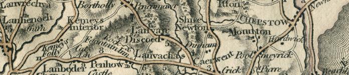
A Parish 6.1/2 miles west-by-south from Chepstow railway station and 4.1/2 miles north-east from Magor station on the South Wales railway; in the Southern division of the county, Caldicot Hundred, Petty Sessional division, Union and County Court district of Chepstow; middle division of Netherwent rural deanery, Monmouth archdeaconry and Llandaff diocese.
The Village of Llanvair Discoed is on the road from Caerwent to Usk, at the foot of a lofty eminence, known as "Mynydd Llwyd," or Grey Hill, from the top of which a magnificent prospect is obtained: on this hill are some vestiges of an ancient stone circle. The Neddern brook flows through the parish.
The church of St. Mary, a building of stone in the Early English style, appears to have been rebuilt in 1746, according to an inscription formerly over the south door; it consists of chancel, nave, south porch and a western bell turret containing one bell: the church was thoroughly restored and enlarged in 1883, the chancel at the expense of the Ecclesiastical Commissioners, and in 1885 the late Col. Kemeys-Tynte gave addition to the yard and built a fence wall surrounding it: there are 110 sittings. The register of Baptisms and Burials dates from the year 1681; Marriages, 1680. The living has been annexed to Caerwent since 1885, gross joint yearly value in 1891 £228, with 5 acres of glebe land and residence, in the gift of the Dean and Chapter of Llandaff, and held since 1882 by the Rev. Thomas Davies Jones, of Hertford College, Oxford, who resides at Caerwent. Parish Clerk: Theophilus Morgan.
On an eminence close by the church are the ruins of the ancient castle, which appears to have been erected in the earlier part of the 13th Century by the noble family of Fitz-Pain, possibly on the site of an older building: the castle was subsequently held by the De Monthermers, and passed from them by marriage to the Montacutes, and afterwards descended to the noble families of Nevile and Pole: having reverted to the Crown in the time of James I, the castle was granted in 1610 to Thomas Woodward, who conveyed it to Rhys Kemeys, ancestor of the present owner, Capt. Kemeys-Tynte: two large round towers, some part of the keep and a portion of the curtain walls remain. The Court House (now a farmhouse, occupied by Mr. Pritchard), is an old building, having an inscription in Welsh above the doorway, signifying, "It is better to write the name of the Most High on stone than with ink."
Post: Letters through Chepstow arrive at 10 a.m. Shirenewton is the nearest money order office, & telegraph office at Sudbrook. Wall letter box cleared at 4.15 p.m.
Schools:
The children of Llanvair Discoed and Dinham attend Caerwent National School.
Capt. Halswell Milborne Kemeys-Tynte, of The Callow Mill, Monmouth, is lord of the manor and principal landowner, The soil is loam; subsoil, gravel. The chief crops are wheat, barley, clover and roots. The area is 1,986 acres; rateable value, £988.
The population in 1881 was 140.
…………
DINHAM
A hamlet 2 miles east and formerly a distinct parish, is one of the few places in Gwent mentioned by name in the Domesday survey. There was a castle here as early as 1128, some vestiges of which are to be found in a thick copse on a steep bank just above a picturesquely wooded dingle, through which one of the old roads leading to Wentwood formerly passed: little more than the foundations of some of the walls remain: the castle was probably erected by some of the family of Le Walleys or Walsh, by whom Dinham was held for many years. In the time of Queen Elizabeth, Dinham was purchased by William Blethyn, Bishop of Llandaff (1575-91), whose descendants resided here in a mansion standing on the site now occupied by Great Dinham Farm: the estate having subsequently passed through several hands came into the possession of the Bayley family and now belongs to Mrs. Bayly, who owns the entire parish with the exception of the glebe and small portions belonging to Edward Joseph Lowe Esq. D.L., F.R.S., J.P. of Shire Newton Hall and Thomas Woodall Esq. of Great Dinham.
Caruth, a famous British bard, resided at Dinham, and refers to it in one of his songs as the burial-place of Caradoc, the great British chieftain, better known as Caractacus, who for nine years kept the Roman legions in check, but was finally defeated at Caer-Caradoc, and sent a prisoner to Rome: he is said to have been permitted to return to his native land, and, according to tradition, his remains rest near to where Dinham Castle afterwards stood.
There was formerly a church at Dinham, some traces of which may be seen at the gable end of one of the farm buildings belonging to Great Dinham Farm: the font is used as a pump-trough in the farm yard and the lid of a stone coffin, locally known as "The Bishop's Stone." is built into the garden wall: the church has been long abandoned and the parish is now united for ecclesiastical purposes with that of Llanvair-Discoed.
At Whitewalls Brake, between Dinham and Caerwent, a tessellated pavement has been found.
The area of Dinham is 671 acres; rateable value, £338.
The population of Dinham in 1891, about 40.
(extracts from Kelly's 1891 Directory of Monmouthshire, transcribed by J. Doe)

Aberbargoed • Aberbeeg • Abercarn • Abergavenny • Abersychan • Abertillery (also see Aberystruth) • Aberystruth • Bettws (near Llantillio Pertholey) • Bettws (near Newport) • Bettws Newydd • Bishton • Blackwood • Blaenavon • Blaina • Briery Hill • Bryngwyn • Bwlch Trewyn • Caerleon or Llangattock-Juxta-Caerleon (see Christchurch for Caerleon Village) • Caerwent • Caldicot • Castleton • Cefnycrib • Chapel Hill • Chepstow • Christchurch (also see Newport) • Clawrplwyf • Coedkernew • Coed y Paen • Crick • Croesyceiliog • Cross Ash • Cross Keys • Crosshands • Crumlin (also see Llanhilleth & Mynyddislwyn) • Cwm (also see Ebbw Vale) • Cwmavon (also see Trevethin) • Cwmbran (also see Llanvihangel Llantarnam & Llanfrechfa) • Cwmcarn • Cwmcarvan • Cwmffrwdoer • Cwmnantddu • Cwmtillery (also see Aberystruth) • Cwmynyscoy • Cwmyoy • Devauden • Dewstow • Dingestow • Dinham • Dixton Newton • Duffryn • Earlswood • Ebbw Vale • Fleur-de-Lys • Freehold • Garndiffaith (also see Trevethin) • Garndyrris • Garnfach • Gellygroes • Glascoed • Goldcliff • Golynos • Govilon • Goytre • Graig • Griffithstown (also see Llanfrechfa & Panteg) • Grosmont • Gwehelog • Gwernesney • Hardwick • Henllys • High Cross • Highmoor Hill • Howick • Ifton • Itton • Kemeys Commander • Kemeys Inferior • Kilgwrrwg • Langstone • Little Mill • Llanarth • Llanbadoc • Llanbedr • Llandavenny • Llandewi Fach • Llanddewi Rhydderch • Llanddewi Skirrid • Llandegveth • Llandenny • Llandevaud • Llandogo • Llanellen • Llanfaeneor • Llanfair Discoed • Llanfair Gilgoed • Llanfair Kilgeddin • Llanfihangel Crucorney • Llanfihangel Gobion • Llanfihangel juxta Roggiett • Llanfihangel Llantarnam • Llanfihangel nigh Usk • Llanfihangel Pont y Moile • Llanfihangel Tafernbach • Llanfihangel Tor y Mynydd • Llanfihangel Ystern Llewern • Llanfihangel y Vedw • Llanfoist • Llanfrechfa • Llangattock • Lingoed • Llangattock nigh Usk • Llangattock Vibon Avel • Llangeview • Llangibby • Llangoven • Llangua • Llangwm Ishaf & Llangwm Uchaf • Llanhennock • Llanhilleth • Llanishen • Llanllowell • Llanmartin • Llanover • Llanrumney • Llansantffraed • Llansoy • Llanthewy Rytherch • Llanthewy Skirrid • Llanthewy Vach • Llanthomas • Llanthony • Llantillio Crossenny • Llantillio Pertholey • Llantrissent • Llanvaches • Llanvair Discoed • Llanvair Kilgeddin • Llanvapley • Llanvetherine • Llanwenarth Citra • Llanwenarth Ultra • Llanwern • Lliswerry • Llwyndu • Machen (Upper & Lower) • Maes-y-cwmmer • Magor • Maindee (also see Christchurch & Newport) • Malpas • Mamhilad • Marshfield • Mathern (also see St Pierre) • May Hill • Michaelston y Fedw • Mitchel Troy • Monkswood • Monmouth • Mounton • Mynyddbach • Mynyddislwyn • Mynyddmaen • Nantyderry • Nantyglo • Nash • New Town • New Tredegar • Newbridge • Newcastle • Newchurch East & West • Newport • Nightingale Village • Oldcastle • Overmonnow • Panteg • Par Grace Dieu • Pen y Clawdd • Penalt • Penbiddle • Pengam • Penhow • Penmaen • Penpergwm • Penrhos • Penrose • Penterry • Pentrepeod • Penygarn • Penyrheol • Peterstone Wentloog • Pillgwenlly • Ponthir • Pontllanfraith • Pontnewydd (also see Llanfrechfa) • Pontnewynydd • Pontrhydyryn • Pontygof • Pontymister • Pontymoile • Pontypool • Pontywain • Porthcasseg • Portskewett • Pwll Du • Pwllmeyric • Raglan • Redbrook • Redwick • Rhydgwern • Rhymney • Risca • Rock • Rockfield • Rogerstone • Roggiett • Rumney • Runston (also see Mathern) • St Arvans • St Brides Netherwent • St Brides Wentloog • St Kingsmark • St Lawrence • St Maughans • St Mellons • St Pierre (also see Mathern) • St Woolos • Sebastopol (also see Panteg) • Shirenewton • Sirhowy • Six Bells • Skenfrith • Snatchwood • Somerton Common • Sudbrook • Talywain (also see Trevethin) • The Race and Upper Race • Tintern Abbey • Tintern Parva • Tranch • Tredegar • Tredunnock • Tregare • Trellech • Trellech Grange • Trevethin • Treworgan • Trostrey • Undy • Upper Machen • Usk • Varteg • Victoria • Waunlwyd • Whitebrook • Whitson • Wilcrick • Wolvesnewton • Wonastow • Wyesham • Ynysddu
All images unless otherwise credited are © MonGenes and may not be reproduced without permission
© MonGenes 2013